
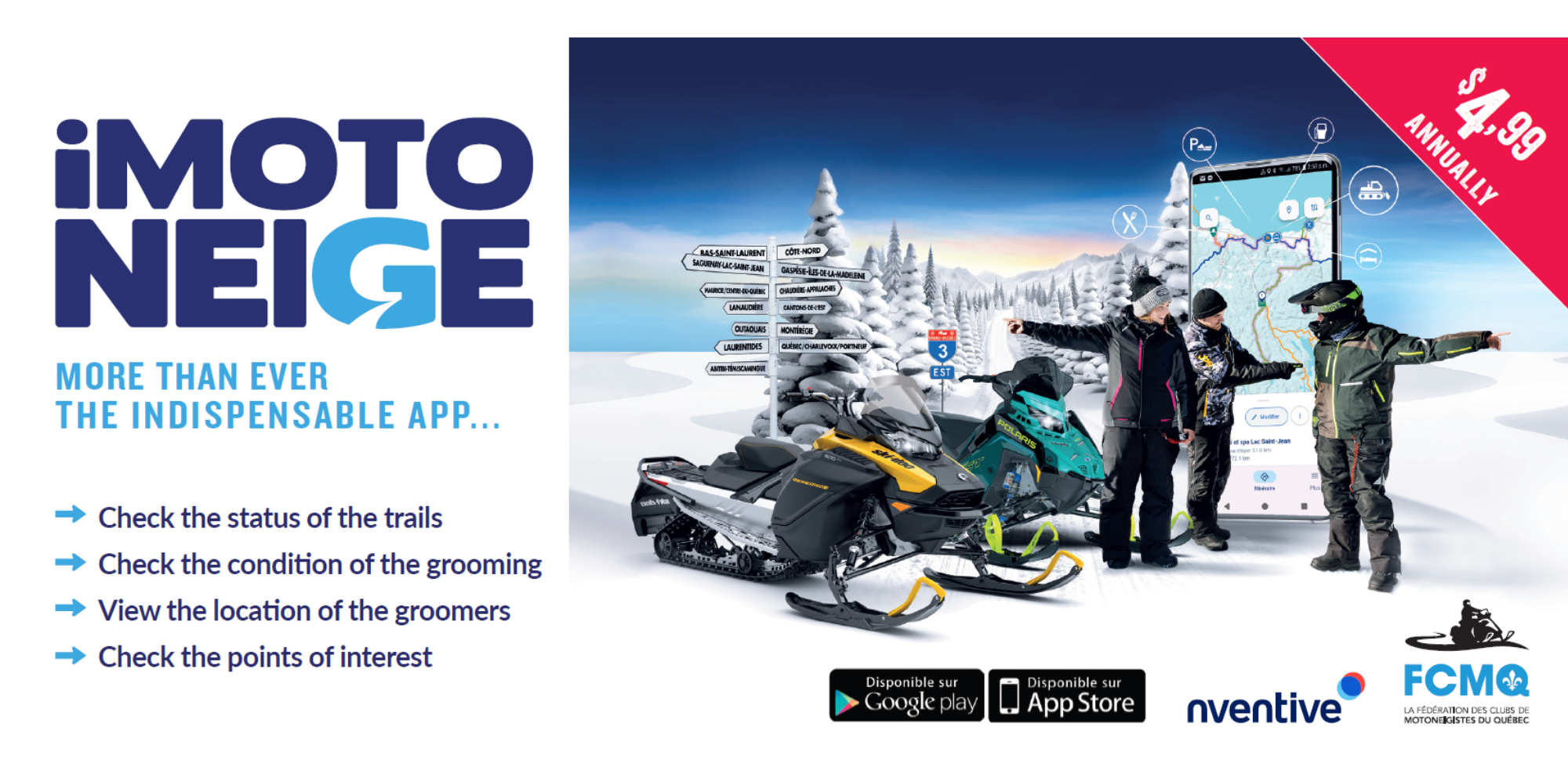
iMotoneige app
To plan your rides with confidence, we recommend using the iMotoneige app or consulting the interactive map.
Developed in partnership with nventive, iMotoneige provides quick and comprehensive access to all snowmobile trails across Québec, even without a data plan or cellular signal.
The iMotoneige app allows you to:
- View the snowmobile trail network
- See your real-time position on the trails
- Check trail status (open or closed)*
- See the date of the last grooming
- Track the movement of groomers on open trails
- View snow accumulation on the ground
- Locate businesses listed by Regional Tourism Associations (ATR): accommodations, restaurants, dealerships, etc.**
- Find FCMQ member hotels, rest stops, shelters, and clubs
- Consult establishment information sheets
- Create your own personalized itinerary and share it by email or text message
- Identify the club responsible for the trail you are riding on
*Trail status is updated by FCMQ member clubs.
**Grooming data comes from GPS units installed on grooming machines.
***To display your business on the interactive map and in iMotoneige, please contact your Regional Tourism Association (ATR).
The app is available in both French and English, depending on your device’s language settings. It is designed for portrait mode use; landscape mode is also possible but will display full screen.
iMotoneige User Guide
Discover everything the iMotoneige app has to offer to make your rides smoother, safer, and more enjoyable. Whether you’re an experienced snowmobiler or new to the sport, this comprehensive guide will walk you through every key feature.
The Interactive Map (Web)
Freely accessible from your computer, the interactive map offers similar features to the iMotoneige app.
In addition, it allows you to:
Create and share an itinerary by email or text message (it will automatically open in iMotoneige on mobile)
Display satellite imagery of the trails and surrounding area
If you would like your business to appear on the interactive map and the iMotoneige app, please contact your Regional Tourism Association (ATR).
We recommend consulting the interactive map or downloading the iMotoneige app to get all the information you need to plan your snowmobile rides.
We invite you to use the iMotoneige app and share your feedback with us via our online customer service.

Definition of Trail Types
Trans-Québec Trail :This trail is unique in that it crosses a minimum of three administrative regions of the FCMQ, also considering a province or state as a boundary.
Regional Trail: This trail is unique in that it crosses 3 municipal entities or 2 regional county municipalities (RCM), with a province or state boundary considered as an entity.
Local Trail: This trail is unique in that it provides access to a service or serves as a connector trail to the Trans-Québec trail or regional trails. There is no numbering designated by the FCMQ for this type of trail.
Display your business on iMotoneige and the interactive map
You are from the Eastern Townships or the Montérégie region and you would like to sign up your business on the interactive map and on the iMotoneige application? To register contact Valérie Ménard, Sales and Marketing Representative, by phone at 438 777-7036 or by email: vmenard@fcmq.qc.ca
We recommend that you consult the interactive trail map or purchase the iMotoneige application to obtain all of the information you need to plan your trips.
We invite you to use the iMotoneige application and to leave us your comments via our online customer service.

